ECEF (toprak merkezli, toprak sabitlenmiş), atalet navigasyonunda ve GNSS tabanlı konumlandırmada kullanılan bir Kartezyen koordinat sistemidir . Hareket ederken gezegenle dönen yeryüzünün merkezine göre yerleri temsil eder
INS/GNSS'de ECEF'in temel özellikleri
• Dünya merkezindeki köken - (0,0,0) noktası Dünya'nın kütle merkezinde yer almaktadır .
• Dünya ile döner - Ataletsel bir referans çerçevesinden farklı olarak ECEF gezegenle döner.
• XYZ Koordinat Sistemi (x, y, z) koordinatları olarak metre temsil edilir .
ECEF Atalet Navigasyonunda Nasıl Kullanılır?
GNSS verilerini INS konumlandırmaya dönüştürür - INS ile entegrasyon için ECEF koordinatlarına dönüştürülen enlem, boylam ve yükseklik sağlar
✔ Doğru konum izleme Dünya yüzeyine göre araç hareketini hesaplamasını sağlar .
✔ Yüksek hassasiyetli navigasyon için gerekli -havacılık, askeri ve otonom navigasyon sistemlerinde kullanılır.
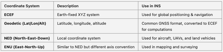
ECEF ve INS'deki diğer koordinat sistemleri